Sunday, 31 January 2010
Cromford, Masson Hill & Bonsall
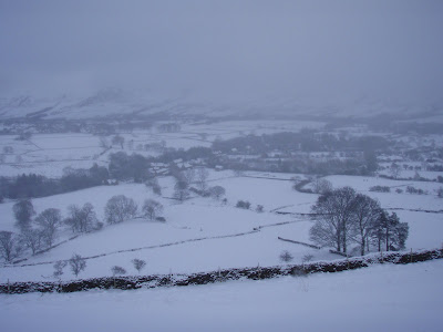
Parked in Cromford opposite the end of Scarthin Lane and climbed up the hillside behind the cottages and over a ridge to drop down behind Cromford Court. As the path started to climb away again we found an adit entrance just to the left of the path, which is marked as a cave on the map. It was quite an interesting little place and I found a bat near the entrance, squeezed into a tiny crack in the roof. We climbed up the side of the valley and eventually came out on the top of Masson Hill before dropping down into Bonsall at the cross. We passed through a large area of what I would imagine were fairly modern mine workings on the way down - must go back for a closer look some time. We sat on the benches by the cross to eat out sandwiches before continuing along the side of the Via Gellia back into Cromford. Went to Scarthin Books for a browse and a cup of a tea and a piece of cake.
Wednesday, 27 January 2010
Castleton / Mam Tor / Cave Dale
When I picked Niki up the weather seemed cold, but fairly calm, but when we emerged from the car in the car park at the back of the Castleton Tourist Information Centre, it became apparent that it was blowing a gale. We parked up in the back streets (because it was going to cost a fiver to park in the car park - how the heck do they justify that much???!!!!!!!!) and joined the others outside the Tourist Information Centre. Myself, Niki and Paul Chandler, of course, plus Ray, Peter, Jill, Phil and finally Rich and collie Robbie.
We set off through the village and took the lane that leads up to Hollins Cross and the stiff climb up, stopping to check out Odin Sough, a really squalid flat out crawl apparently, with nowhere to turn around - hm, might give that one a miss!!!

Once we got onto the ridge it was too cold and windy to stop, but by the time we got to the top you couldn’t walk straight or even stay on your feet easily, it was so windy. I thought I was going to have to crawl the last section onto the path down. There was a certain amount of slightly hysterical laughter as we reached the gate at the bottom of the path, with Ray calling Paul something unpleasant!!

We went to stop in the quarry behind Windy Knoll, but it was still so windy that I jumped over the fence and we dropped down through the snow into the cave itself, where it was considerably warmer and sheltered.


We set off through the village and took the lane that leads up to Hollins Cross and the stiff climb up, stopping to check out Odin Sough, a really squalid flat out crawl apparently, with nowhere to turn around - hm, might give that one a miss!!!

Peter investigating Odin Sough.
Once we got onto the ridge it was too cold and windy to stop, but by the time we got to the top you couldn’t walk straight or even stay on your feet easily, it was so windy. I thought I was going to have to crawl the last section onto the path down. There was a certain amount of slightly hysterical laughter as we reached the gate at the bottom of the path, with Ray calling Paul something unpleasant!!

Crossing the Chapel road below Mam Tor
We went to stop in the quarry behind Windy Knoll, but it was still so windy that I jumped over the fence and we dropped down through the snow into the cave itself, where it was considerably warmer and sheltered.


After lunch we continued up to the track to Rowter Farm and then across the fields...

Starting up the track towards Rowter Farm

Getting past some of the gates was really easy for all of us except Robbie!

to the top of Cave Dale. There was a short shower of squally light rain as we entered the dale, but it was dry by the time we got back to the car.

Dropping down Cave Dale
Sunday, 24 January 2010
Hartington / Biggin Dale / Wolfscote Dale / Beresford Dale
We did a slightly different version of this favourite walk, which involved following Hall Bank, but instead of turning into Reynards Lane, we continued up the hill, past the YHA and turned right into the fields. This took us across the fields and onto a Highfields Lane, which drops to a lane at the very top of Biggin Dale. Highfields Lane was often blocked with deep drifts of snow.


Snowdrifts blocking Highfields Lane.
Once in Biggin Dale itself, we followed it gently downhill past a water treatment works and into a field, where the valley continued. There was a dew pond on the right and sadly several large and very deceased toads, apparently drowned when ice entirely covered the pond. In this area there is a move to put dew ponds back in working order so that amphibians have several to choose from that are close enough together for them to move between. I definitely approve!!
We continued down the valley to where Reynards Lane joins the dale and then on down past what is marked on the map as a cave, but is actually a mine trial. We have explored it before, so we continued to the bottom of the dale and our usual 'picnic' site. On this occasion we weren't alone as several men with lurcher type dogs and guns were floating around the bottom of Biggin Dale and into downstream Wolfscote Dale and along the valley side to Dove Valley Farm. I don't know what they were after, but it didn't bode well for something cute and furry.

The view from our picnic spot into downstream Wolfscote.
We turned upstream and followed the water's edge.

Wolfscote Dale, shortly upstream from where Biggin Dale joins.
Further upstream, we passed the Frank o' the Rocks caves high up on the eastern side of the valley. Again, we'd visited them before several times, so we continued on past some springs and into the rather boggy fields beyond.

Frank o' the Rocks Caves.
At the far side of the fields, we crossed a bridge and effectively left Wolfscote Dale and entered Beresford Dale, but still following the river.

Beresford Dale.
Beresford Dale has a very different feel to Wolfscote Dale and the house perched up on top of the crags to the western side of the valley gives it a feel of a private valley somehow. At the upstream end, we crossed one of the many wooden bridges and up a small rise into the last few fields back into Hartington.

Looking back across the fields to Beresford Dale, hidden in the trees.
Saturday, 23 January 2010
Ashford-in-the-Water, Monsal Dale, Deep Dale and Sheldon
It was quite a dull morning when we left home, but it brightened up as the day went on. We parked up in Ashford-in-the-Water, had a brief look at the Sheepwash Bridge...

and then set off across the fields and along a couple of lanes in the general direction of Monsal Dale.


We emerged above Monsal Dale and followed the valley top along towards Monsal Head and then turned back along the valley side to drop down to the river and a large weir.

Just down river from the weir we crossed a bridge and spent the next half mile or more following the river downstream to the A6 and White Lodge car park. After a brief visit to their really rather nice composting toilets, we followed the path towards Taddington Dale and soon came across a stream, where there wasn't a stream the last time we were there!!


After enjoying our sandwiches, we followed the path and entered Demon's Dale itself, a small ravine that leads into Deep Dale itself. Although, strictly speaking, the path does not follow this ravine, we decided to see if we could make it through following the water. As water levels were quite high, it was a bit damp in places, but much more fun than going over the crag above.

We had a bit of fun getting back onto the path, but once we had we followed the valley upstream. The water disappears quite suddenly underground...

as it emerges from Hubberdale Sough and just up the valley from there is one of the shafts into Hubberdale Mine itself. The Orpheus spent a lot of time back into the sixties digging in the mine.

Shortly after leaving the shaft, we turned left up that side of the valley to a gate.

Up here, we found several still deep patches of snow that persist even weeks after most of it has long gone.

From the top of the valley we crossed several fields and entered to the southwest of the village of Sheldon. One option here was to cross to the far side of the village and the site of Magpie mine, but having visited there several times before, we chose to walk down the main (only) street through Sheldon. At the lower end, we turned left into the fields and passed to the right of the top of Little Shacklow Woods and followed what is probably an old miners' track, green and sunken across the fields down to the road.

A short distance down the lane we came to the A6 and turned right to return to Ashford-in-the-Water and the old bridge.

Sheepwash Bridge and Fennel Street beyond.
and then set off across the fields and along a couple of lanes in the general direction of Monsal Dale.

The view back towards Ashford-in-the-Water and Bakewell.

Monsal Dale.
We emerged above Monsal Dale and followed the valley top along towards Monsal Head and then turned back along the valley side to drop down to the river and a large weir.

The weir just down river from Monsal Head.
Just down river from the weir we crossed a bridge and spent the next half mile or more following the river downstream to the A6 and White Lodge car park. After a brief visit to their really rather nice composting toilets, we followed the path towards Taddington Dale and soon came across a stream, where there wasn't a stream the last time we were there!!

Water... where once there was none!

Demon's Dale Cave, which was completely dry on our previous visit.
After enjoying our sandwiches, we followed the path and entered Demon's Dale itself, a small ravine that leads into Deep Dale itself. Although, strictly speaking, the path does not follow this ravine, we decided to see if we could make it through following the water. As water levels were quite high, it was a bit damp in places, but much more fun than going over the crag above.

The lower end of Demon's Dale - it narrows considerably around the corner!
We had a bit of fun getting back onto the path, but once we had we followed the valley upstream. The water disappears quite suddenly underground...

Water emerging from Hubberdale Sough.
as it emerges from Hubberdale Sough and just up the valley from there is one of the shafts into Hubberdale Mine itself. The Orpheus spent a lot of time back into the sixties digging in the mine.

Paul peering down the shaft into Hubberdale Mine.
Shortly after leaving the shaft, we turned left up that side of the valley to a gate.

Looking back down Deep Dale.
Up here, we found several still deep patches of snow that persist even weeks after most of it has long gone.

Paul seems unable to resist standing in the snow drifts!
From the top of the valley we crossed several fields and entered to the southwest of the village of Sheldon. One option here was to cross to the far side of the village and the site of Magpie mine, but having visited there several times before, we chose to walk down the main (only) street through Sheldon. At the lower end, we turned left into the fields and passed to the right of the top of Little Shacklow Woods and followed what is probably an old miners' track, green and sunken across the fields down to the road.

The sunken, green miners' path down to Ashford-in-the-Water.
A short distance down the lane we came to the A6 and turned right to return to Ashford-in-the-Water and the old bridge.
Sunday, 17 January 2010
Youlgreave & Bradford Dale
Paul and I had originally planned to do a walk that took in most of Lathkill Dale too. We parked up at Alport and tried to follow Lathkill Dale upstream, but as before when I tried this with Mum and Dad, the river was up, full of melt water, and the field was completely flooded.

So we decided to modify our walk somewhat (probably more than halved it!!!) and headed off up the road and through Youlgreave itself. It's a really nice village with plenty of services and it was one of just two villages that we considered moving to when we found Kirby House (the other being Tideswell, which was really a bit far north).


We followed the main street right through the village and continued along the road, taking a left turn towards Middleton. On the second tight bend, the second valley that the road contoured around, we took a footpath that dropped us down the valley...

and we emerged above the bridge in between the fish ponds in Bradford Dale.

The path along the main valley was absolutely treacherous with ice and after skating our way through the gate, we tottered along on the edge furthest from the water. We stopped at one of the weirs and I took a photo looking back upstream. When I turned back to Paul I saw that he was taking a photograph of the bare branches of an ash tree on the other side of the river. There was piece of bright turquoise plastic caught on a branch, or so I thought, until it moved and turned to look at me!! It was a beautiful little kingfisher, sat on a branch with it's back to us. I'd never realised that they have a brighter turquoise patch on their backs. Paul took some photos of it, which came out really quite well. See Paul's blog.
We continued down the valley, bumped into Ben Stevens and his girlfriend Susan, who were also out walking, and emerged into the open valley. Normally if I go walking in Bradford Dale (usually with my friend Joan) I leave my car at the bottom of Mawstone Lane, but we still had to walk through to Alport, so we crossed the lane and continued along the river.

When we reached the village we left the footpath right by the river and it became apparent just how high water levels were when you saw how little of the arch was left under the bridge. The water was within six inches of the top of the wall of the garden on the far side of the water!!


The flooded footpath heading upstream into Lathkill Dale.
So we decided to modify our walk somewhat (probably more than halved it!!!) and headed off up the road and through Youlgreave itself. It's a really nice village with plenty of services and it was one of just two villages that we considered moving to when we found Kirby House (the other being Tideswell, which was really a bit far north).

Looking north towards Lathkill Dale.

One of the many very nice large houses just outside the village.

The Bulls Head Hotel, one of three pubs in Youlgreave.


The village fountain.

Another very nice house near the centre of the village.
We followed the main street right through the village and continued along the road, taking a left turn towards Middleton. On the second tight bend, the second valley that the road contoured around, we took a footpath that dropped us down the valley...

Paul on the steep and very icy path down into Bradford Dale.
and we emerged above the bridge in between the fish ponds in Bradford Dale.

Looking back upstream in Bradford Dale.
The path along the main valley was absolutely treacherous with ice and after skating our way through the gate, we tottered along on the edge furthest from the water. We stopped at one of the weirs and I took a photo looking back upstream. When I turned back to Paul I saw that he was taking a photograph of the bare branches of an ash tree on the other side of the river. There was piece of bright turquoise plastic caught on a branch, or so I thought, until it moved and turned to look at me!! It was a beautiful little kingfisher, sat on a branch with it's back to us. I'd never realised that they have a brighter turquoise patch on their backs. Paul took some photos of it, which came out really quite well. See Paul's blog.
We continued down the valley, bumped into Ben Stevens and his girlfriend Susan, who were also out walking, and emerged into the open valley. Normally if I go walking in Bradford Dale (usually with my friend Joan) I leave my car at the bottom of Mawstone Lane, but we still had to walk through to Alport, so we crossed the lane and continued along the river.

Downstream towards Alport.
When we reached the village we left the footpath right by the river and it became apparent just how high water levels were when you saw how little of the arch was left under the bridge. The water was within six inches of the top of the wall of the garden on the far side of the water!!

The road bridge in Alport.
Saturday, 16 January 2010
Shopping with Pete
After spending the previous weekend lying on the sofa with an exploding head, aching body and temperature, I wasn't really that enthused about getting changed in near freezing temperatures and going into Water Icicle, so when Pete decided that his back wasn't up to plowing through snow drifts and going underground, I was quick to offer to keep him company for a few hours.
We walked back down into the village and then drove to Hitch 'n' Hike to pick up the 200m of rope for the Cave Exploration Award. I promised to send Shaun a photo of the gruesome twosome with it. We then drove back the way we'd come to Calver Crossroads and went to Outside for a cuppa (and some tiffin for me) and then on to Matlock to investigate the antique shops, looking for a coat stand for Pete. We had no luck, but headed into Bakewell to take a look at the antique shops there - they're a bit more up market, so I didn't really hold much hope.
Eventually, we gave up and headed back to Kirby House for a cup of tea/coffee, and to wait for Paul and Keith to return from Monyash cafe.
Wednesday, 6 January 2010


Saturday, 2 January 2010
Kinder
Got up at 8am and drove out to Edale through snow showers.
Followed the road through the village, stopping at the Tourist Information Centre on the way, and walked up onto Ringing Roger. The cloud was very low and it was snowing and quite windy, but management at that point. We stopped in amongst the rocks at the top and spotted a hare and a few grouse not far below us, sheltering from the wind. We had a bite to eat and a hot drink, sheltering from the wind and tucked in under Paul's two-man shelter. It was quite toasty.


Once we left the shelter of Ringing Roger rocks though, it was quite a different story. The snow was powder apparently and very different to walk in than the snow in the Lakes, plus it was considerably deeper most of the time.
The path at the top of Ringing Roger is non-existent, which freaked me out and even once we found the path along the edge, we soon lost it again as it was covered in so much snow. A lot of the time the conditions were too much for my liking - goggles would have been useful, I just kept following Paul's heels. I wondered more than once if I would make it back down, especially as we passed the Grindsbrook route that everyone else seemed to be taking.
We continued along the edge and followed the path out towards Grindsbrook Knoll. We had to leave the path and go over the top of the hill when the path was banked with snow and impossible to follow. After that the path began to drop back down to Edale and it was more sheltered.

Followed the road through the village, stopping at the Tourist Information Centre on the way, and walked up onto Ringing Roger. The cloud was very low and it was snowing and quite windy, but management at that point. We stopped in amongst the rocks at the top and spotted a hare and a few grouse not far below us, sheltering from the wind. We had a bite to eat and a hot drink, sheltering from the wind and tucked in under Paul's two-man shelter. It was quite toasty.

Paul at our lunch break spot.

Poor Piglet!!!!

Snowy rocks.
Once we left the shelter of Ringing Roger rocks though, it was quite a different story. The snow was powder apparently and very different to walk in than the snow in the Lakes, plus it was considerably deeper most of the time.
The path at the top of Ringing Roger is non-existent, which freaked me out and even once we found the path along the edge, we soon lost it again as it was covered in so much snow. A lot of the time the conditions were too much for my liking - goggles would have been useful, I just kept following Paul's heels. I wondered more than once if I would make it back down, especially as we passed the Grindsbrook route that everyone else seemed to be taking.
We continued along the edge and followed the path out towards Grindsbrook Knoll. We had to leave the path and go over the top of the hill when the path was banked with snow and impossible to follow. After that the path began to drop back down to Edale and it was more sheltered.

The route down from Grindsbrook Knoll.

The village of Edale below.
Friday, 1 January 2010
New Year's Day Walk - Bakewell / Ashford-in-the-Water
We left Keith and Pete getting breakfast and were defrosting my car when Niki & Mat drove down the hill. Met them and the rest – Paul C, Peter & Christine, Scott and one other lady – in Holme Lane, Bakewell.
Had a look at a couple of the entrances to Holme Bank Chert Mine, which were steaming gently - the air escaping from the mine was positively warm - and then set off up the fields and over the hill to drop down through Cracknowl Wood onto the A6020 near Ashford.
We stopped in Ashford for a bite to eat and then set off up the hill opposite the bridge above Arrock Black Marble Mine...


and along the lane to drop back into the fields.


Scott spent the walk throwing stones onto every pond we came to and even slid across one of them, but the largest one that we encountered right near the end of the walk, he wisely decided was perhaps a bit dodgy. When the top layer of ice was broken there were two other layers below it and the whole thing was extremely creaky around the edges.
We finally dropped back into Bakewell near the church and had a look at some stone coffins propped up at the back of the building and then inspected the gravestone of White Watson (who has something to do with mining, but sadly I wasn't listening at this point, so I missed what was said), before returning to the cars.

Had a look at a couple of the entrances to Holme Bank Chert Mine, which were steaming gently - the air escaping from the mine was positively warm - and then set off up the fields and over the hill to drop down through Cracknowl Wood onto the A6020 near Ashford.

The view across Ashford towards Longstone Edge.

Walking along the lane.
and along the lane to drop back into the fields.

The view across the fields back towards Bakewell.

The view further south to the woods above Haddon Hall.
Scott spent the walk throwing stones onto every pond we came to and even slid across one of them, but the largest one that we encountered right near the end of the walk, he wisely decided was perhaps a bit dodgy. When the top layer of ice was broken there were two other layers below it and the whole thing was extremely creaky around the edges.
We finally dropped back into Bakewell near the church and had a look at some stone coffins propped up at the back of the building and then inspected the gravestone of White Watson (who has something to do with mining, but sadly I wasn't listening at this point, so I missed what was said), before returning to the cars.

Stone coffins propped up at the back of Bakewell church.
Subscribe to:
Comments (Atom)