Wednesday 24 February 2010

Middleton Top, Slaley, Ible, Grangemill, Limestone Way, High Peak Trail

Niki phoned me just after I got up and said that she was up for a walk and there hadn't been much snow after all. I picked her up at Bank Top, as usual, running a bit close to time, but it only took us ten minutes to drive to Middleton Top.

We congregated in the icy car park and set off soon after 10am - Peter, Paul C, Jill, Mike, Phil and us. Peter said he'd been persuaded to join us, but he planned to take a short cut.

We set off across the fields to Middleton in thick fog, turned down the road towards the Via Gellia, then picked up a footpath that took us across a field and into the woods down the steep side of the valley. We took a short detour to Good Luck Mine...


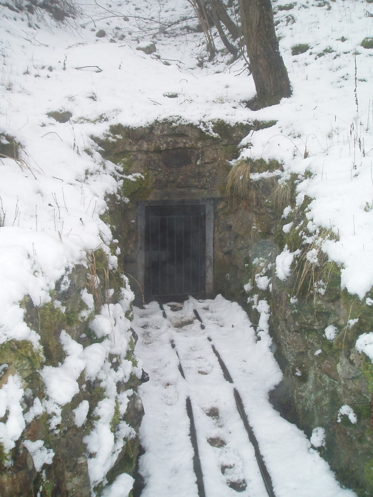
The gated entrance to Good Luck Mine

L-R:  Phil, Peter, Paul, Jill, Mike and Niki

and sat in the coe and had a hot drink before continuing down to the Via Gellia. We followed the road around the bend - Niki found a nice shovel on the way (as you do) - and took a small path up the hillside on the other side of the valley, which was steep and slippy. Just below a pump house we crossed a couple of streams and continued up the hill to the east-ish to Slaley. We then followed the muck wagon a short way up the hill and popped into the Bonsall Moor fields and out onto the lane again, effectively cutting the corner. I got very confused at that point about what part of the Limestone Way we were on and suggested that we were heading for Winster, but actually we were on the Ashbourne section, so headed for Ible, as intended.

The lone figure of Peter disappearing into the clag

Peter left us at Leys Farm and we became six as we continued on across the fields to Ible - what an odd place, no more than half a dozen houses and a couple of farms clinging to the top of the hill. Cute cows though!!


We then followed a lane down to the main road and headed down to Grangemill and the Hollybush.  The pub was closed (it's up for sale again), so we sat on some benches around the side and had our butties, which was pretty chilly and the road was busy so it was pretty noisy too, but it was somewhere to sit.

Lunch over, we crossed the junction diagonally and continued up a track...


Prospect Quarry, on the northern side of the Via Gellia

A dead pylon near the quarry

that took us around the back of Longcliffe Quarry.  By this time the fog was beginning to lift a bit.

Longcliffe Quarry - this is only a small part of it

It's big!! As we continued along the Limestone Way, we came over the top of the hill and within view of the B5062 again - I never even realised there was a footpath up there!


We went to the wrong corner of the last field, but soon clambered over a stone stile onto the High Peak Trail - thank God! We still had a good walk, mostly in deep slush, but at least we were on the home straight. We passed Harborough Rocks and followed Manystones Lane...

Trees looming in the fog on the other side of Manystones Lane

through a tunnel...


and back to Middleton Top. I was so knackered and stiff! Why does walking on the flat always do that to me?

Sunday 21 February 2010

Robin Hood's Stride in the snow

We woke up and found that six inches of snow had been dumped overnight and the world had turned white all over again.  In the early afternoon, we decided to go out for a walk.  We went out onto the Limestone Way, up to Robin Hood's Stride, then back down to the road, up onto the knoll at the end of Birchover Wood, along the footpath above Birchover Wood, visited the emus at Upper Town farm and then back across to Winster.  It was surprisingly tiring!!

Grey Tor

The Limestone Way

Looking across the fields towards Elton

Robin Hood's Stride

Looking south towards Winster

Saturday 20 February 2010

Stoney Middleton, Eyam & Foolow

Had breakfast at Outside. Parked at the A623 car park at the bottom of Stoney Middleton Dale and walked back down through the village, past the 'Roman' baths (which aren't Roman, but are thermal) to pick up a track. We followed the track up to a lane where we got some fantastic views of the eastern edges.

The view north towards Grindleford


Crossing the lane we headed into a field, up through a small valley in the woods and out onto another lane.

 Looking south across Stoney Middleton Dale and Coombs Dale

We turned left onto the lane and followed it a short way to a stile into the field where the 'Riley Graves' are, where the Hancock(e) family is buried.

The Riley Graves

The information board at the bottom of the lane reads:

"You will see grave stones where Mrs Hancock buried her husband and six children, victims of the plague, between the 3rd and 10th August 1666.  The Hancock's farmed this field, known as Riley's field.
Riley comes from 'Rois Ley's', which means 'King's Field'. It was part of William the Conqueror's Royal Hunting Ground."

After taking some photos of the gravestones, we followed the lane the rest of the way down into Eyam. Turning right by a café with a phenomenal choice of cakes, we followed Water Lane up out of the village, and picked up a path that rises steeply across fields, up through the woods...


Looking southwest to the western most end of Stoney Middleton Dale


Looking back down the hill to Eyam

and out onto the edge before heading further north onto a lane, which we crossed and continued north past Ladywash Mine...

Ladywash Mine

Ladywash farm...

Ladywash Farm

and out onto Sir William Hill Lane.

Sir William Hill Lane

We turned left onto that too and followed it out onto the lane that runs along the top of the ridge to Bretton and the The Barrel Inn pub. We took the left fork just past the pub and dropped down towards Foolow. We stopped for lunch just north of the village at a 'wayside' well.


Wayside well just north of Foolow

Stone cross and Methodist chapel in Foolow

As we left Foolow, we heard the sound of many horses following us through the village and then had an entertaining time watching the hunt riding across the fields, jumping walls (or not!) and generally going around in circles, as we headed across the fields towards Eyam. We finally dropped down a large open 'park-like' field, and down through the village.

The Eyam village 'map' at the craft centre

Sundial on Eyam church

Celtic Cross, thought to date from the 8th century, in Eyam churchyard

The boards list the huge variety of cakes that this cafe in Eyam has

We stopped off at the cake café for tea and a hot sausage roll, and then followed Lydgate Lane out of Eyam, across the fields to the main field on the hill past the boundary stone.

The boundary stone

In 1666, during the outbreak of plague in Eyam, the story goes that the villagers left money for their supplies in the holes on the top of the stone, filled with vinegar to sterilise the coins.

The Derwent Valley

Paul on the path down to Stoney Middleton - note the north facing slope opposite

Sunday 14 February 2010

Longnor, High Wheeldon & Pilsbury Castle

Parked in Longnor and headed back out the way we'd come in. Turned left into a lane that lead to a footpath across the fields to the lane past Alderley Cliff. There was a group of people orienteering on bicycles that were rather annoying, but I'd got out of bed the wrong side, so that didn't help.

Looking across the Dove valley from Longnor towards High Wheeldon

We dropped down steeply from the village, crossed the valley and on meeting the road turned left up the hill to the base of High Wheeldon on the right and Aldery Cliff.  We went to take a closer look at the climbs...

Aldery Cliff

and the old Orpheus dig (with the ubiquitous gigantic pile of mud and stones outside - 'Ken woz 'ere').

 The gated entrance to one of the Aldery Cliff Caves

- the crag looks very interesting and definitely worth a visit in the summer. We then trudged up High Wheeldon...

Looking back down to Aldery Cliff.

right onto the top and then back down the north ridge to take a look at the entrance to Fox Hole Cave.

 Looking down the north ridge of High Wheeldon Aldery Cliff,
with Paul stood near the entrance to Fox Hole Cave

After having a brief snack and hot drink in the comparative shelter of the cave entrance...

Entrance to Fox Hole Cave on High Wheeldon

we continued south down the valley, crossed the road just above Crowdecote and on up the bottom of the valley to finally arrive at Pilsbury Castle, where we stopped for lunch.

 Approaching Pilsbury Castle

There were some sheep in the field, as usual, but one ewe had two tiny lambs with her, much to the consternation of another ewe to whom they ran - she turned tail and 'ran away'!

As we dropped back down to the Dove we encountered a group of off-road bikers tearing up the countryside and making a hideous racket. Our way continued along the route we take when we do the Hartington/Pilsbury walk, except that instead of turning off the sunken lane that runs straight up the side of the ridge, we continued right to the top. The track should have been a pleasant walk except that it had just been torn up by the bikes coming down it and it was really muddy and slippy.

From there we walked about a mile along the lane back towards Longnor, until we reached a track on the left down to Over Boothlow, which we followed down the side of the ridge and then turned north along the Manifold valley and into the back of the village.

Wednesday 10 February 2010

Hartington / Biggin Dale / Wolfscote Dale / Alstonefield

Got up later than usual, got my sustenance together and left the house just as Niki arrived at the door at 9:30. It only took quarter of an hour to drive to Hartington and there was no-one else in sight, so we booted up and wandered along to the loos and back. By that time Paul was there and Jill and then Phil and Dave pulled up. We headed off up the lane (Hall Bank) and onto Reynards Lane (the way Paul and I have always gone until the other week).

 Looking back across Hartington

Biggin Dale

We turned down Biggin Dale and stopped briefly at the adit for a break.

 Adit entrance in Biggin Dale

Niki and I, with Jill on the first section, went and explored the adit to the forefield - nothing much to see really, but a bit of nice crystal in places and some very nice pick marks.

 Lower Biggin Dale

When we got to Wolfscote Dale, we turned downstream and followed the river and a heron to Coldeaton Bridge.

Crossing Coldeaton Bridge

By this time it was trying to snow and as we headed up the steep hillside, it started to come down in earnest.


By the time we passed the YHA and turned out onto the road into Alstonefield, everything was covered in an inch of snow!
 

We headed to the pub in Alstonefield and made use of the benches outside to have our butties, by which it was sunny again and the snow started melting again - strange weather!!

 Walking through Alstonefield

We left Alstonefield on a lane towards Hulme End and then after missing it initially took a bridle path that lead into the fields where Paul and I went doing the Millers Dale/Alstonefield walk last year.

Looking back across the fields

 Looking north towards Hartington

A day of very strange weather!

Instead of dropping down the field though, we stayed up high and contoured around the top of Narrowdale Hill and then dropped steeply down into Narrowdale buildings. From there we followed the route that Paul and I did, down to the bridge near to Frank o' the Rocks caves, along Beresford Dale and back across the fields to Hartington.